If I asked you to draw a map of your home-town from memory, what would you draw? Before you pick up your pencil, there’s something else. Imagine you have never before seen a map. It’s impossible, right? Because we are surrounded by maps, and have been since we were little. My father had a map book of the South Island in the glove-box of his car and I was obsessed by the tiny winding roads, town names, bridges and harbours. In 1841 Edmund Halswell, Commissioner for the Management of Native Reserves in Aotearoa (New Zealand), commissioned several Ngāi Tahu men to create for him a map of the South Island. But before the Europeans arrived, Māori people did not have drawn maps. Māori maps were verbal—places and waterways were named as ancestors, or as myths, or drawn into complex stories repeated in chants, songs, prayers, and whakapapa (genealogies).
The map that the Ngāi Tahu men drew for Halswell is beautiful and strange. You can find a copy of it here. It is rich with intimate experience. Some areas are too large, crammed with detail, other areas too small, vacant, unimportant to these map-makers. The emphasis is on the borders between land and sea; safe and dangerous harbours, hidden rocks, islands, and seals. There are many place names, most of them Māori, and brief descriptions—large river, strong tides, nearly dry at the mouth, good anchorage. Plenty of natives. Plenty of whites. The land itself is blank. It’s likely Halswell wasn’t interested in having a map of the land at this stage. It was a matter of safely landing European sailing ships and survey men first.
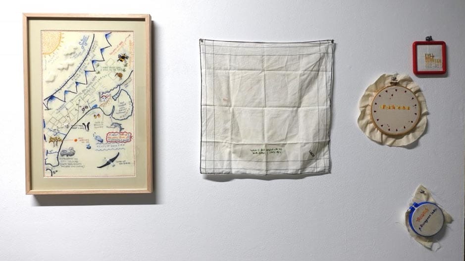
I decided to make a map of my home town in response to this Ngāi Tahu map, and I tried to imagine myself without the knowledge of a formal map, giving myself the freedom to stitch Christchurch as a child might. In stitching a map, I followed a tradition begun in the eighteenth century, when school children translated geography lessons into fabric maps.
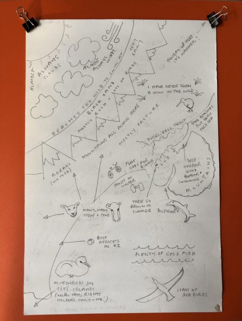
I imagined mapping Christchurch for a visitor who has never been—what they will see, where they should go swimming, what the hills look like in summer, what the weather will most likely be. I stitched a map of experience. What was important for me could be bigger, what was unimportant, smaller.
To draw a place as a child remembers it is to surrender to inaccuracy, to exaggeration. It is to return to a world that is as bright and crisp as a Christchurch summer’s day, where inside the car, on the way to the beach, the sun is blissfully warm, but on exiting the car with togs and towel you are hit with that perpetual cold wind. I picked up the pencil, and I started with the sun and the wind and the clouds. Many childhood experiences are on the map—cold hands biking to school protected by home-made mittens, but some things reflected more recent memories. I don’t recall knowing what a muttonbird was when I grew up, but this map is an exploration of belonging now, how I was/am Pākehā but am also Ngāi Tahu. The muttonbird chick, young and vulnerable, felt like a powerful symbol of this.
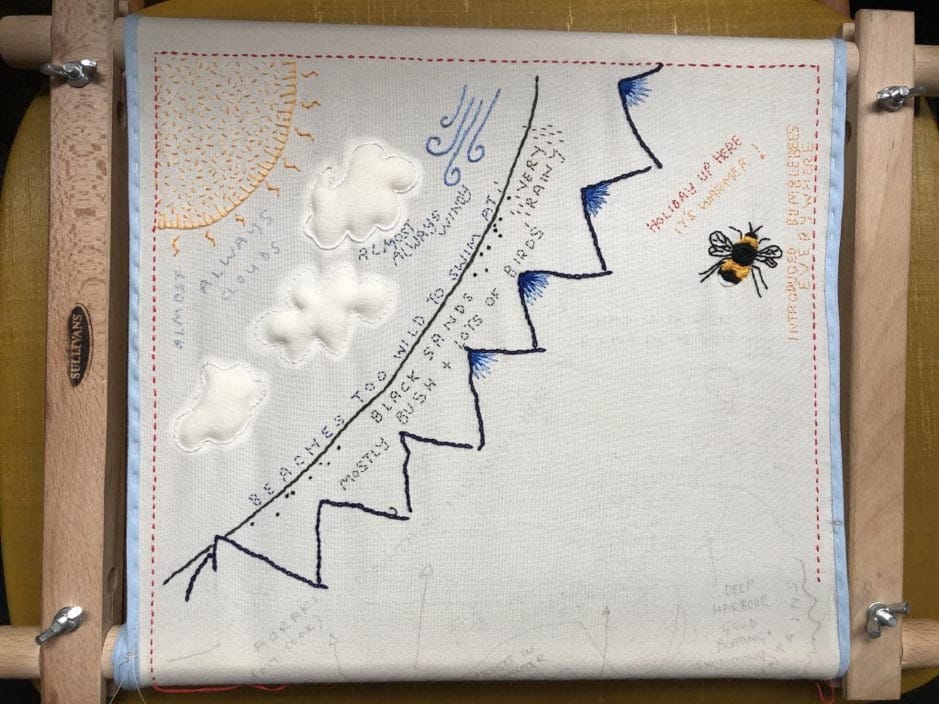
First came the drawn pattern—a map for the embroidery—then I transferred the pattern to the fabric and started to stitch. I started with the sun in the top left-hand corner. Once outlined, I filled it in with seed stitch, two shades of yellow to give it movement and shimmer. When I finished there was more empty fabric than stitch in my sun, but stitches change everything—they are like words in a poem—the sum so much more than its parts. It’s a vast improvement on my drawing! I learned how to make the fat white clouds that almost always float over Aotearoa in an embroidery class. Then I outlined the coast and began on the Southern Alps. Later, I returned to the land outline, having realised something was missing, and I added a twisting blue line where the sea meets the earth.
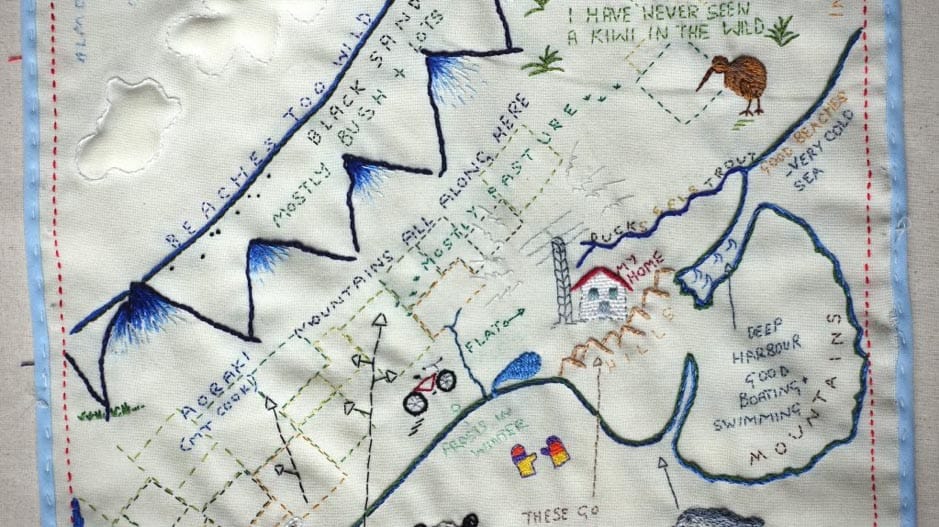
As I slowly stitched, making decisions as I went about colour and pattern, memories surfaced, and I made some additions. I added our house, and then dad’s tall, spindly ham radio-tower in the back yard because the two belong together. I thought about how surprised my stepdaughters were when they first saw a bumblebee (we don’t have them in Melbourne), so I stitched this fat, cheerful insect. I added apricot trees, rivers, and paddocks.
I read that maps almost always have a title, so I stitched a title that recalls the early times of map-making. But I stitched in a mistake. Surrounds is missing its n. I did not even see this, and yet I knew there was something strange about this part of the embroidery because my eye would linger there. Then my friend, an editor, visited the exhibition where the embroidery was hung and she pointed it out.
First Site Gallery, RMIT University, August 2019
What an incredible oversight! To be blind to this mistake, while I finished the embroidery, washing and dried it, took it to the framers. I wonder, did the Ngāi Tahu men make mistakes in their map? Did they argue about what went where, or a name? Did they, on their return to the South Island, recall features they had missed? I would argue their map is memorable precisely because it is imperfect, imprecise, filled up with personal knowledge. Knowledge that is always fallible. Fallibility is certainly there in my map, but I hope that it might be memorable too, this stitched recollection of childhood, mistakes and all. See more images of this work here.